Loading

Aerial images for Farming, Environment & Energy

Farming, Environment & Energy

Aerials shots not only give a scenic panorama, aerials shots can a lot more than that. Thanks to precise GPS navigation spots, drone shots help by the measurement of rural areas, the reorganization of parcels but also in the wind power and agriculture sector.
The geographic system of information gives to aerial shots the possibility to influence green building, development of villages and building planning.
Aerial images can provide a very important assistance, precisely when it is about building plots, local constructions and management of land use in the environnement and energy sector.
Furthermore, drone shots can be very helpful in the case of a final evaluation of newly created structures as well as for your concluding presentation.

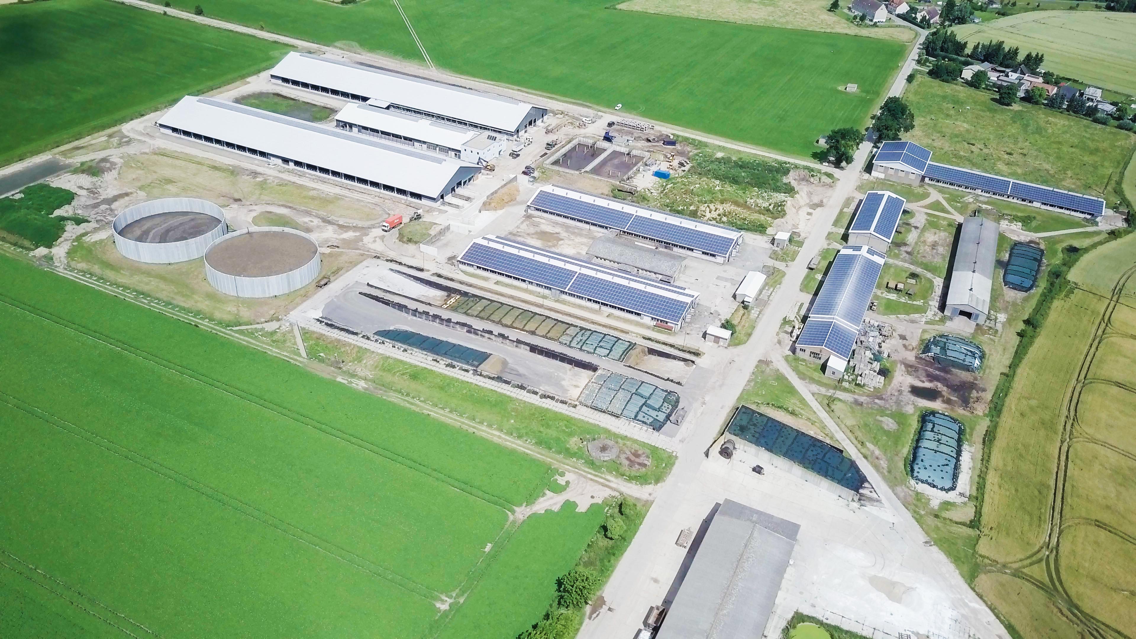
LGSA // Dairy cattle in Wallstawe

The agricultural agency from Sachsen-Anhalt commissioned us to fly over the dairy cattle of Wallstawe.

The newly build cowshed and the large scale solar system on the rooftops were in focus for this film.

Through to the optimum positioning of the drone thanks to the most modern sensors, it is also possible to securely control the drone , even in the most difficult locations and to obtain the desired images.

ARGE construction documentation // Ground restructuration procedure in Pabstorf

The agricultural agency from Sachsen-Anhalt commissioned us to document the procedure of restructuration of the ground in Pabstorf.

During 3 different construction phases we filmed the site with our drone which led to the realization of an edited film.

We flew over more than 20 locations in Sachsen-Anhlat, from the highway 14 through Colbitz to the dairy cattle in Wallstawe.

[om_cc_vc_grid_element post_type=”page” number=”4″ base_cell=”horizontal” filter_type=”project” order_by=”title” order=”ASC” use_img=”yes” hover_time_animate=”0.5″ bg_visibility_lg=”app” bg_time_animate=”0.4″ bg_time_delay=”0″ bg_back_time_animate=”0.2″ bg_back_time_delay=”0″ title_visibility_lg=”disapp” title_size_unit_lg=”em” title_padding_unit_lg=”%” title_animate=”rest” title_time_animate=”0.4″ title_time_delay=”0″ title_back_time_animate=”0.2″ title_back_time_delay=”0″ extra_visibility_lg=”app” extra_position_lg=”top” extra_padding_unit_lg=”%” extra_animate=”rest” extra_time_animate=”0.4″ extra_time_delay=”0″ extra_back_time_animate=”0.2″ extra_back_time_delay=”0″ caption_time_animate=”0.4″ caption_time_delay=”0″ caption_back_time_animate=”0.2″ caption_back_time_delay=”0″ title_size_unit_md=”em” extra_size_unit_md=”em” cols_sm=”2″ bg_visibility_sm=”yes” title_visibility_sm=”yes” cols_xs=”1″ item_padding_left_filter=”12″ item_padding_top_filter=”6″ padding_left_filter=”0″ padding_top_filter=”0″ width_mobile_filter=”100″ filter_projects=”555,532,521,508″ post_exclude=”true” project_settings_color=”false” gutter_lg=”0″ bg_color_hover_lg=”rgba(15,243,208,0.75)” title_source_lg=”post_title” extra_source_lg=”post_excerpt” gutter_sm=”0″ gutter_xs=”0″ extra_padding_top_lg=”20″ extra_padding_right_lg=”10″ extra_padding_bottom_lg=”25″ extra_padding_left_lg=”10″ extra_color_lg=”#ffffff” extra_color_hover_lg=”#ffffff” title_size_lg=”2″ title_padding_right_lg=”10″ title_padding_left_lg=”10″ title_color_lg=”#ffffff” title_padding_top_md=”15″ title_padding_right_md=”15″ title_padding_bottom_md=”15″ title_padding_left_md=”15″ title_color_md=”#ffffff” extra_padding_top_md=”15″ extra_padding_right_md=”15″ extra_padding_bottom_md=”15″ extra_padding_left_md=”15″ extra_color_md=”#ffffff” extra_color_hover_md=”#ffffff” title_color_sm=”#ffffff” title_color_xs=”#ffffff” title_size_md=”1.3″ extra_size_md=”0.9″]